Geology & Soils
The land beneath Wild Roots tells a story spanning 200 million years — from Jurassic limestone to Quaternary sand dunes. Understanding this foundation is key to restoration.
Geological Setting
Wild Roots sits within the Algarve Basin, a Mesozoic sedimentary basin at the southwestern tip of the Iberian Peninsula.
The Algarve Basin
The Algarve Basin formed during the breakup of Pangaea in the Triassic period (~230 Ma) as the Iberian Plate separated from North Africa. Through the Jurassic and Cretaceous, thick sequences of carbonates, marls, and evaporites accumulated in shallow tropical seas.
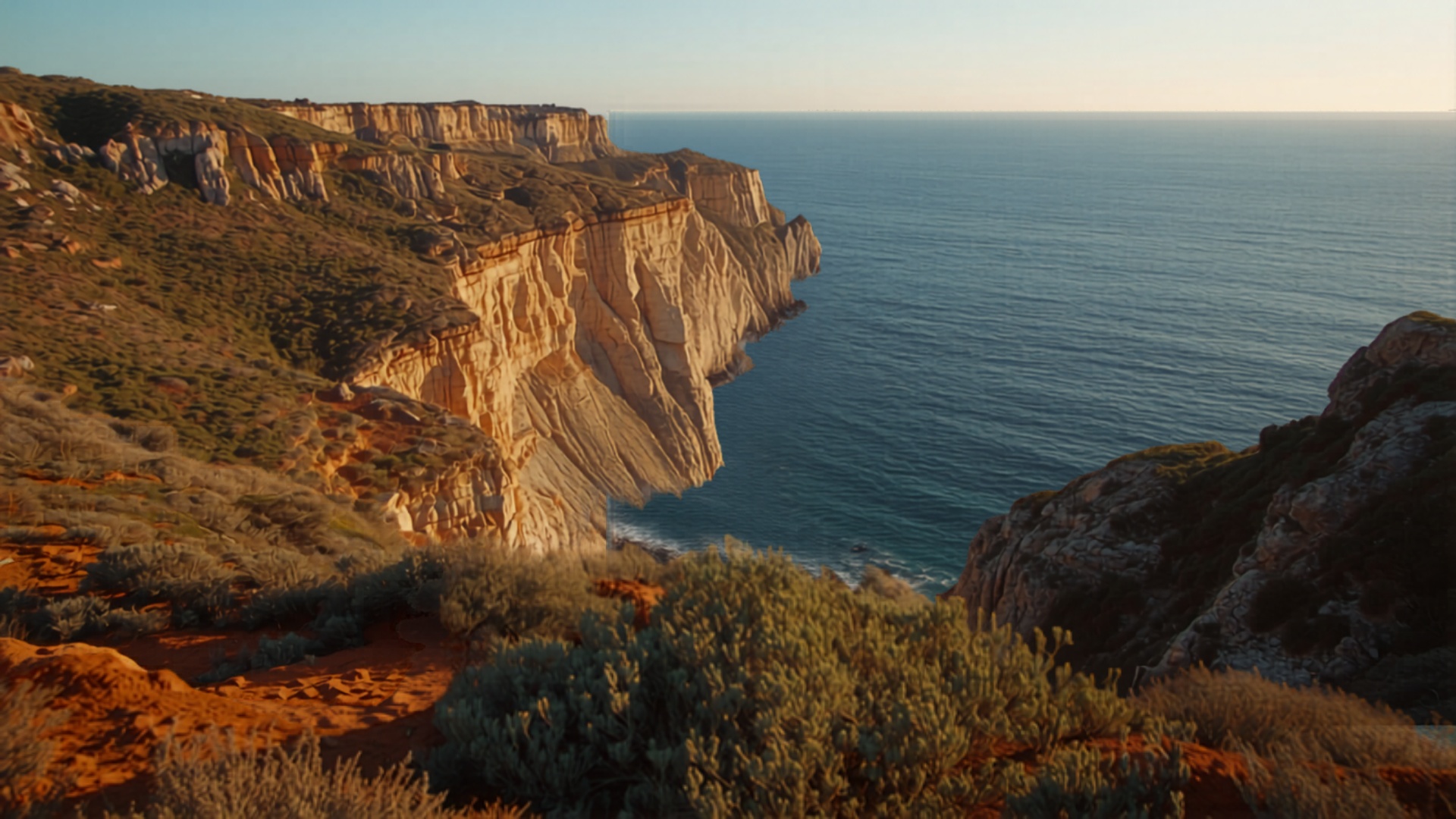
Vila do Bispo occupies the western margin of this basin, where the dominant Jurassic and Cretaceous carbonates give way to younger Miocene and Plio-Pleistocene cover sequences. The site lies just 3 km from the Costa Vicentina cliffs, which expose a continuous section through 150 million years of Earth history.


Site Geomorphology
The Wild Roots terrain reflects its geological substrate: gently undulating surfaces on the Plio-Pleistocene sands give way to steeper, rockier slopes where limestone approaches the surface. This topographic diversity creates multiple microclimates and soil niches — a major advantage for biodiversity restoration.
Drone mapping reveals a 45-metre elevation range across the 2.325 ha property, with seasonal watercourses following fault-controlled valleys.

150 Million Years of Earth History
Visible in the cliffs, soils, and landforms of Vila do Bispo
Stratigraphic Column
The principal rock formations underlying and surrounding the Wild Roots site, from oldest to youngest.
Upper Jurassic Limestones
Massive to bedded limestones and dolomites. These karstified carbonates form the regional aquifer system and underlie much of the Vila do Bispo plateau. Rich in fossil bivalves, gastropods, and coral fragments. Outcrop along the coastal cliffs reveals spectacular karst morphology.
Lower Cretaceous Marls & Limestones
Alternating sequences of marls, marly limestones, and clay-rich layers. These softer formations form gentle slopes and control local drainage patterns. Key horizon for groundwater flow barriers.
Miocene Biocalcarenites
Fossiliferous sandstones and calcarenites deposited in shallow warm seas. These yellowish formations are visible along the Algarve coast and provide excellent building stone. Rich in marine microfossils indicating tropical-subtropical paleoenvironments.
Plio-Pleistocene Red Sands
Iron-rich fluvial and aeolian sands that blanket much of the Algarve plateau. These characteristically red-orange deposits (locally called "areias vermelhas") form the parent material for the dominant Cambisol soils on the Wild Roots site.
Quaternary Dunes & Alluvium
Coastal dune systems, colluvial deposits, and thin alluvial fills in valleys. These youngest deposits include the consolidated dune-rock (eolianite) visible at nearby beaches and the loose sandy soils in topographic lows on the property.

Written in the Soil
Each layer tells a story of climate, biology, and geological time
Soil Types on Site
The Wild Roots land encompasses several distinct soil types, each supporting different plant communities and requiring different restoration approaches.

Reading the Soil
Decades of eucalyptus monoculture stripped organic matter and depleted soil biology. Our restoration strategy begins with understanding what each soil type needs — from pH adjustment to mycorrhizal inoculation.
Soil sampling across 12 points on the property revealed pH ranges from 5.0 to 8.2, organic matter from 0.8% to 4.2%, and depths from shallow rock (<20 cm) to deep sand profiles (>1 m).

Cambissolos (Cambisols)
The predominant soil type. Moderately deep (40–80 cm), well-drained, slightly acidic (pH 5.5–6.5). Developed on the Plio-Pleistocene red sands. Good potential for permaculture once organic matter is restored.

Litossolos (Leptosols)
Thin soils (<20 cm) directly on limestone bedrock. Found on exposed ridges and steeper slopes. Alkaline (pH 7.5–8.2) with high carbonate content. Supports native maquis vegetation.

Arenossolos (Arenosols)
Deep sandy soils in lower areas. Very low water retention and nutrient holding capacity. pH 5.0–6.0. Home to specialist species like Tuberaria major. Requires biochar and compost amendments.

Fluvissolos (Fluvisols)
Alluvial soils in valley bottoms and seasonal watercourses. Deeper (1 m+), higher organic content, periodic waterlogging. Supports riparian vegetation and is ideal for food forest zones.
Water Systems
Understanding water flow is essential for permaculture design, pond restoration, and irrigation planning.
The Wild Roots site lies above the Querça-Silves Aquifer System (M11), one of the most important groundwater bodies in the Algarve. This karstified Jurassic limestone aquifer extends over 318 km² and feeds numerous springs along its southern boundary.
Surface hydrology is dominated by seasonal patterns: winter rains saturate the thin soils and fill temporary ponds, while summer drought requires careful water harvesting and storage strategies aligned with permaculture keyline principles.

Groundwater
Karst aquifer in Jurassic limestone. Traditional well on site. Water quality: good, calcium-bicarbonate type, suitable for irrigation and domestic use after filtration.
Surface Water
Seasonal streams (ribeiras) active Oct–May. Mediterranean temporary ponds fill in winter. Zero surface flow June–September. Keyline design captures maximum rainfall.
Geological Map
LNEG Sheet 51-A (Vila do Bispo) — the official geological survey of the region.

From Geology to Restoration
Understanding the ground beneath us shapes every decision we make
Implications for Restoration
Geology and soils dictate what we can grow, how we manage water, and where we build.

Geology Meets Architecture
Geotechnical investigations at the ruin site confirmed what the geological map suggested: shallow Jurassic limestone lies within 60 cm of the surface, overlain by Cambisol. This ideal substrate allows shallow strip foundations for the new hempcrete structure.
The local limestone itself becomes a building resource — crushed stone aggregate from site clearing feeds the foundation mix, closing the material loop.
Soil Restoration
The Cambisol-dominated soils have been degraded by decades of eucalyptus monoculture. Organic matter levels have dropped to 0.8–1.2% — target is 3–5%. Strategy: chop-and-drop mulching, biochar integration, cover cropping with nitrogen-fixers, and mycorrhizal inoculation from remnant native woodlands.
Building Foundations
The variable geology — from shallow limestone to deep sands — requires careful foundation design. Geotechnical surveys indicated that the hempcrete structure can use shallow strip foundations on the Cambisol/limestone transition, avoiding the expensive deep piling that pure sand would require.
Water Management
Permaculture keyline design follows the contours revealed by geological mapping. Swales are positioned along soil-type boundaries to intercept lateral flow, while check dams in ephemeral channels slow winter runoff and recharge the shallow aquifer.
Explore the Science
Dive deeper into the environmental data behind Wild Roots — from climate analysis to biodiversity mapping.